
About
AccessMod 5 is a World Health Organization (WHO) tool, and previous versions have been developed thanks to the support of the WHO Department of Health Systems Governance and Financing (WHO/HIS/HGF), the University of Geneva/Institute of Global Health/GeoHealth group, the AeHIN GIS Lab, the WHO eHealth unit (WHO/IER/KMS/EHL), the WHO department of Making Pregnancy Safer (WHO/FCH/MPS), the GEOmatics for Informed DEcisions (GEOIDE) Networks of Centres of Excellence, the Faculty of Medicine/University of Sherbrooke, and the School of Mathematical and Geospatial Sciences/RMIT University/Melbourne.
From 2018 to 2021, UNICEF contributed to the maintenance of AccessMod 5 and the development of new functionalities.
The license attached to AccessMod 5 is the GNU GPL V3. However, there is an additional WHO “TERMS OF USE AND SOFTWARE LICENSE AGREEMENT” that you must agree to in order to use AccessMod 5.0. Please read this document carefully when downloading AccessMod.
Since 2022, AccessMod is a Digital Public Good, part of the Digital Public Goods Alliance.
This website is about the AccessMod project, which is broader than the AccessMod tool as it also includes its many applications, academic works, teaching material, articles/reports by University of Geneva, AeHIN GIS Lab, and other authors, etc.

The process
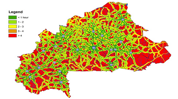
AccessMod (version 5) is a free and open-source standalone software to model how physically accessible existing health services are to the target population, to estimate the part of the target population that would not receive care despite being physically accessible due to shortage of capacity in these services (human or equipment), to measure referral times and distances between health facilities, and to identify where to place new health facilities to increase population coverage through the scaling up analysis.

Step 1
PREPARE YOUR INPUT DATA
Use your favorite GIS software and spreadsheet to prepare your geospatial and tabular data
The tools
AccessMod 5 is composed of five main tools

Accessibility analysis
Compute the traveling time surface, informing the time needed to reach the nearest health facility

Geographic coverage analysis
Take into account the coverage capacity of each health facility to estimate the part of the target population that would not receive care despite being physically accessible

Referral analysis
Calculate travelling times and distances separating different types of health facilities

Zonal Statistics
Obtain the percentage of the population being covered in each sub national division

Scaling up analysis
Identify the optimum location for building new health facilities
Download
The code of AccessMod is based on several open source libraries and tools (e.g. GRASS, gdal, R, shiny), packaged in a virtual machine, which makes it easy to use and install on any desktop computer, without worrying about dependencies and configurations, license fees or operating system (AccessMod 5.0 can run under Windows, Mac, Linux,..). Since version 5.7.x, Accessmod runs under Docker and can also be used in with Docker installed on the user's machine. The graphical user interface of AccessMod is accessed through you web browser (e.g. Chrome, Firefox).
To run AccessMod, most users will first need to install the free virtual machine manager VirtualBox. Refer to the user manual for further installation instructions. Once installed, please update the software directly from the user interface, as frequent updates are available.
Version 5.8
The user manual and tutorial contains all you need to get started and master AccessMod through step-by-step exercises using the provided sample data sets
(older versions: 5.1.12, 5.3.2, 5.6)
Version 5.8
Most users will use the *ova file to be run with VirtualBox on Windows, Mac, or Linux if VirtualBox is installed
Visit the VirtualBox website to get the latest version of the software for your operating system

Publications
Selected peer-reviewed articles using AccessMod
Hierink F, Oladeji O, Robins A, Muniz M, Ayalew Y & N Ray. 2023. Implementing the primary healthcare roadmap in Ethiopia: a mixed geospatial analysis of accessibility and availability. Communications Medicine, 3: 140 Link to article
Molenaar L, Hierink F, Brun M, Monet J-P & N Ray. 2023. Travel scenario workshops for geographical accessibility modelling of health services: a transdisciplinary evaluation study. Frontiers in Public Health, 10:1051522 Link to article
Simonin VT, Vaghefi SA, Abdelgadir ZM, Eltayeb D, Sidahmed MAM, Monet J-P & N Ray (2023). Present and future drinking water security and its impacts on maternities: a multi-scale assessment of Sudan. International journal of environmental research and public health, 20(3): 2204 Link to article
Ochoa C, Rai M, Babo Martins S, Alcoba G, Bolon I, Ruiz de Castañeda R, Sharma SK, Chappuis F & N Ray (2023). Vulnerability to snakebite envenoming and access to healthcare in the Terai region of Nepal: a geospatial analysis. The Lancet Regional Health – Southeast Asia, 9: 100103 Link to article
Macharia PM, Moturi A, Mumo E, Giorgi E, Okiro EA, Snow RW & N Ray (2022). Modelling geographic access and school catchment areas across public primary schools to support subnational planning in Kenya. Children's Geographies, 1-17 Link to article
Oliphant NP, Sy Z, Koné B, Berthé M, Beebe M, Samake M, Diabaté M, Tounkara S, Diarra B, Diarra AB, Diawara CH, Yakimova T, Florisse S, Jackson D, Ray N & T Doherty (2022). Improving the efficiency of scale-up and deployment of community health workers in Mali: a geospatial analysis. PLoS Global Public Health, 2(10): e0000626. Link to article
Chênes C, Giuliani G & N Ray (2021). Modelling physical accessibility to public green spaces in Switzerland to support the SDG11. Geomatics, 1: 383-398 Link to article
Oliphant NP, Ray N, Bensaid K, Ouedraogo A, Ghali AY, Habi O, Maazou I, Panciera R, Muñiz M, Manda S, Sy Z, Jackson D & T Doherty (2021) Optimising geographical accessibility to primary health care: a geospatial analysis of community health posts and community health workers in Niger. BMJ Global Health, 6: e005238 Link to article
Poirier O, Ruiz de Castañeda R, Bolon I & N Ray (2021). Modelling forest degradation and risk of disease outbreaks in mainland Equatorial Guinea. Journal of Public Health and Emergency, 5:15 Link to article
Hierink F, Rodrigues N, Muñiz M, Panciera R & N Ray. 2020. Modelling geographical accessibility to support disaster response and rehabilitation of a health care system: An impact analysis of Cyclones Idai and Kenneth in Mozambique. BMJ Open, 10: e039138 Link to article
Joseph NK, Macharia PM, Ouma PO, Mumo J, Jalang’o R, Wagacha PW, Achieng VO, Ndung'u E, Okoth P, Muñiz M, Guigoz Y, Panciera R, Ray N & EA Okiro. 2020. Spatial access inequities and childhood immunisation uptake in Kenya. BMC Public Health, 20: 1407 Link to article
Ebener S, Stenberg K, Brun M, Monet J-P, Ray N, Sobel H, Roos N, Gault P, Morrisey Conlon C, Bailey P, Moran AC, Ouedraogo L, Kitong J, Ko E, Sanon D, Jega FM, Azogu O, Ouedraogo B, Osakwe C, Chimwemwe Chanza H, Steffen M, Ben Hamadi I, Tib H, Haj Asaad A, Tan Torres, T (2019). Proposing standardised geographical indicators of physical access to Emergency Obstetric and Newborn Care in low- and middle-income countries. BMJ Global Health 4: e000778 Link to article
Schmitz MM, Serbanescu F, Arnott GE, Dynes, M, Chaote, P, Msuya, AA, Chen, YN (2019). Referral transit time between sending and first-line receiving health facilities: a geographical analysis in Tanzania BMJ Global Health 4: e001568 Link to article
Schmitz MM, Serbanescu F, Kamara V, Kraft JM, Cunningham M, Opio G, Komakech P, Conlon CM, Goodwin MM (2019). Did Saving Mothers, Giving Life Expand Timely Access to Lifesaving Care in Uganda? A Spatial District-Level Analysis of Travel Time to Emergency Obstetric and Newborn Care. Glob Health Sci Pract 7(Suppl 1):S151-S167 Link to article
Ouma PO, Maina JK, Thuranira PN, Macharia PM, Alegana VA, English M, Okiro EA, Snow RW (2018). Access to emergency hospital care provided by the public sector in sub-Saharan Africa in 2015: a geocoded inventory and spatial analysis. Lancet Global Health. 6. e342–e350 Link to article
No Chen Y, Schmitz MM, Serbanescu F, Dynes MM, Maro G, & MR Kramer (2017). Geographic Access Modeling of Emergency Obstetric and Neonatal Care in Kigoma Region, Tanzania: Transportation Schemes and Programmatic Implications.
Glob Health Sci Pract 5(3): 430-445 Link to article
Macharia PM, Odera, PA, Snow, RW & AM Noor (2017). Spatial models for the rational allocation of routinely distributed bed nets to public health facilities in Western Kenya. Malaria Journal 16(367): 1-11 Link to article
Aoun N, Matsuda H & M Sekiyama (2015). Geographical accessibility to healthcare and malnutrition in Rwanda. Social Science & Medicine 130: 135-145 Link to article
Huerta Munoz U & C CK Källestål (2012). Geographical accessibility and spatial coverage modeling of the primary health care network in the Western Province of Rwanda. International Journal of Health Geographics 11:40 Link to article
Alegana VA, Wright JA, Pentrina U, Noor AM, Snow RW & PM Atkinson (2012). Spatial modelling of healthcare utilisation for treatment of fever in Namibia. International Journal of Health Geographics 11:6 Link to article
Costa C, Santana P, Almendra R, Freitas P & A Zaky (2009) And when there is no information? The case of São Tomé and Principe. Instituto Marquês de Valle Flôr. II International Conference on Sustainability Measurement and Modelling Proceedings; 5 November, Spain Link to pdf
Ebener S, Naphini P, Fleming P, Kafakalawa W, Kondowe OD, Makwiza I, Manda K, Mzembe J & C Moyo (2009). Analysing geographic coverage of ART clinics using GIS: example of collaboration between several institutions in Malawi Link to pdf
Ray N & Ebener S (2008). AccessMod 3.0: computing geographic coverage and accessibility to health care services using anisotropic movement of patients. International Journal of Health Geographics 7: 63 Link to article
Reports or studies using AccessMod
UNFPA (2020). Brun, M., Monet, J.-P., Agbigbi, Y., Lysias, J., Moreira, I., M. Schaaf and N. Ray. Implementation manual for developing a national network of maternity units - Improving Emergency Obstetric and Newborn Care (EmONC). UNFPA, 165 p. Link to manual
USAID (2016). Nigeria - Accessibility to EmONC facilities in the State of Cross River. USAID. 61 pages Link to report
USAID (2016). Nigeria - Accessibility to EmONC facilities in the States of Ebonyi and Kogi. USAID. 91 pages (link to follow)
USAID (2015). Malawi - Accessibility to EmONC facilities. USAID. 50 pages (link to follow)
WHO (2015). Investing the Marginal Dollar for Maternal and Newborn Health (MNH):
o Accessibility to EmOC services in Burkina Faso (English)
o L'accessibilité géographique aux services SONU au Burkina Faso (French)
o Accessibility to EmOC services in Cambodia (English)
o Accessibility to EmOC services in Lao People's Democratic Republic (English)
o Accessibility to EmOC services in Malawi (English)
McCracken S, Acire G and F Kaharuza. (2014). Addressing Maternal Mortality: Using GIS for Evaluating Access to EmOC in the SMGL Project in 4 Districts of Western Uganda. CDC. Link to poster
Rashid H, Farooq M, Naseem G, Ahmad M and S Aasif Farooq (2013). Geospatial modeling approach for planning healthcare network - a model study in Jammu & Kashmir, India. Link to report
Contacts
The AccessMod project is co-directed by
Prof. Nicolas Ray and Dr. Steeve Ebener
AccessMod 5 lead developer is Frederic Moser
Prof. Nicolas Ray
GeoHealth group
Institute of Global Health
University of Geneva – Switzerland
Email: nicolas.ray@unige.ch
Web: https://www.unige.ch/geohealth
Developer:
Frederic Moser
GeoHealth group
Institute of Global Health
University of Geneva – Switzerland
Email: frederic.moser@unige.ch
Dr. Steeve Ebener
MORU/Health GeoLab Group
Manila – Philippines
Email: steeve@tropmedres.ac
Web: https://www.tropmedres.ac/units/moru-bangkok/epidemiology/our-team-1/health-geolab
WHO contact:
Karin Stenberg
Economic Analysis and Evaluation team
Department of Health Systems Governance and Financing (HGF), World Health Organization, Geneva – Switzerland
E-mail: stenbergk@who.int